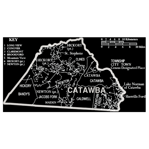
Catawba County
Catawba County has a population of 154,810, according to the 2010 census. Its county seat is Newton and its largest city is Hickory.
Catawba County is part of the data center corridor. Maiden is home to the Apple iCloud data center, and Conover is home to the ncDataCampus and the largest privately owned solar farm in the United States operated by Apple.
The county was formed in 1842 from Lincoln County. It was named for the Catawba tribe of Native Americans who once inhabited the area. German Lutheran farmers settled the area in the 1700’s.
The county has a total area of 414 square miles, of which 400 square miles is land and 14 square miles (3.27%) is water.
With approximately twenty freight trains a day, Catawba County is a freight railroad transportation center. This is largely due to the area’s strong manufacturing based economy, and its placement along the Norfolk Southern Railway line. The Caldwell County Railroad also serves the county and interchanges with Norfolk Southern in Hickory.
The county is divided into eight townships.
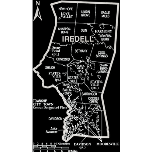
Iredell County
Iredell County had a population of 159,437 according to the 2010 census. Its county seat is Statesville; its largest town is Mooresville. It is named for James Iredell, a justice of the Supreme Court of the United States.
According to the U.S. Census Bureau, the county has a total area of 597 square miles, of which 576 square miles is land and 21 square miles (3.59%) is water.
Iredell County is located within the Piedmont Region of central North Carolina. The northwestern section of the county contains the Brushy Mountains, a deeply eroded spur of the Blue Ridge Mountains far to the west. The highest point in Iredell County, Fox Mountain, is in the Brushies; it rises to 1,760 feet. Although the “Brushies”, as they are often called locally, are not high in the normal sense, they do rise prominently above the surrounding countryside. The remainder of Iredell County consists of gently rolling countryside occasionally broken by low hills and small river valleys. The county’s largest river, the Catawba, forms much of its western border. Lake Norman, North Carolina’s largest man-made lake, is the most prominent geographic feature of southern Iredell County; it is often called North Carolina’s “inland sea”.
Iredell County is an important transportation center for the state, as Interstate 77 and Interstate 40 cross in northeast Statesville. This has given birth to the county’s slogan “Crossroads for the Future.”
Iredell County is one of the longest counties in the state and stretches for nearly fifty miles north to south from Yadkin County in the north to Mecklenburg in the south. The county is divided into seventeen townships.
Iredell County is a major hub of NASCAR racing, with many race shops located in the county (mostly around Mooresville). Many NASCAR drivers live around Mooresville and Lake Norman. Although northern Iredell County has retained much of its rural character, the southern half of the county is experiencing rapid growth, largely due to the immense popularity of the Lake Norman area for residents of nearby Charlotte, North Carolina’s largest city.
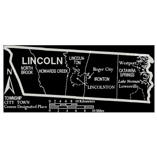
Lincoln County
Lincoln County, North Carolina has an estimated population of 79,740. The county seat is located in Lincolnton. The county was formed in 1779 from the eastern part of Tryon County and was named for Benjamin Lincoln, a general in the American Revolutionary War.
In 1782, the southeastern part of Burke County was annexed to Lincoln County. In 1841, parts of Lincoln County and Rutherford County were combined to form Cleveland County. In 1842, the northern third of Lincoln County became Catawba County and in 1846, the southern half of what was left of Lincoln County became Gaston County.
According to the U.S. Census Bureau, Lincoln County has a total area of 307 square miles, of which, 299 square miles of it is land and 8 square miles of it (2.68%) is water. The population density is 213.5 people per square mile.
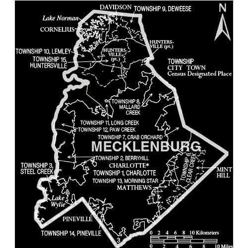
Mecklenburg County
Mecklenburg County is both the most populated and densely populated county in North Carolina. On September 12, 2013, the county welcomed its one millionth resident.
The county seat and largest city is Charlotte.
Mecklenburg County was formed in 1762 from the western part of Anson County. It was named in commemoration of the marriage of King George III to Charlotte of Mecklenburg-Strelitz. Due to unsure boundaries, a large part of south and western Mecklenburg County extended into areas that would later form part of the state of South Carolina. In 1768, most of this area (the part of Mecklenburg County west of the Catawba River) was designated Tryon County, North Carolina. Determining the final boundaries of these “western” areas between North and South Carolina would become a decades- long process. In 1792 the northeastern part of Mecklenburg County became Cabarrus County. Finally, in 1842 the southeastern part of Mecklenburg County was combined with the western part of Anson County to become Union County.
The Mecklenburg Declaration of Independence was allegedly signed on May 20, 1775; if the document is indeed genuine, Mecklenburg County was the first part of the Thirteen Colonies to declare independence from Great Britain.
According to the U.S. Census Bureau, the county has a total area of 546 square miles of which 526 square miles is land and 20 square miles (3.65%) is water.
The county’s primary commercial aviation airport is Charlotte Douglas International Airport in Charlotte.
Light rail service in Mecklenburg County runs from Uptown to Pineville. Currently a 9.6-mile line, build-out is expected to be complete by 2034.
Charlotte Area Transit System (CATS) bus service serves all of Mecklenburg County, including Charlotte, and the municipalities of Davidson, Huntersville, Cornelius, Matthews, Pineville, and Mint Hill.
Mecklenburg’s manufacturing base, its central location on the Eastern Seaboard and the intersection of two major interstates in the county have made it a hub for the trucking industry.
The major industries of Mecklenburg County are banking, manufacturing and professional services, especially those supporting banking and medicine. Mecklenburg County is home to six Fortune 500 companies, including 21st-ranked Bank of America.
Population grew 2.5% per year from 1970 to 2008.
Mecklenburg County contains seven municipalities including the City of Charlotte and the towns of Cornelius, Davidson, and Huntersville (north of Charlotte); and the towns of Matthews, Mint Hill, and Pineville (south and southeast of Charlotte). A small portion of the town of Stallings is also in Mecklenburg County, though most of it is in Union County. Extraterritorial jurisdictions within the county are annexed by municipalities as soon as they reach sufficient concentrations.